Star Tallahassee logo - link to main homepage

Sign In


  • Residents
    • Change for Change
    • DigiTally
    • Ethics Board
    • Fire
    • Neighborhood Services
    • Newsroom
    • OpenGov
    • Parks and Trails
    • Pet Adoption
    • Police
    • Public Safety
    • Public Transportation
    • Traffic
    • Title VI
    • Utilities
  • Business
    • Community Redevelopment
    • Job Openings
    • Online Permitting
    • City Owned Real Estate
    • Vendor Information
    • Procurement
    • Economic Vitality
    • Employee Login
  • Visitors
    • Airport
    • Arts & Culture (COCA)
    • Events
    • Fire
    • Parks and Activities
    • Police
    • Senior Center
    • Visit Tallahassee
  • Our City
    • 2023 Budget
    • Charters/Ordinances
    • Citizen Advisory Boards
    • City Attorney
    • Inspector General
    • City Leadership
    • City Treasurer-Clerk
    • Community Redevelopment
    • Current Projects
    • OpenGov
    • Retirement
    • Tallahassee Brand Library
    • WCOT City Television
    • Ethics Board
    • Strategic Plan
  • Services
    • Airport
    • Animal Services
    • Community Redevelopment
    • City Leadership
    • Current Projects
    • Diversity & Inclusion
    • Employment
    • Environmental Practices
    • Financial Transparency
    • Fire
    • Growth Management
    • Neighborhood Services
    • Newsroom
    • Parks & Recreation
    • Police
    • Procurement
    • Public Safety
    • Public Transportation
    • Senior Services
    • Real Estate Management
    • Report a Problem
    • Utilities
    • Traffic
    • WCOT City Television
    • PLACE
      Planning, Blueprint, Minority Business, Economic Vitality
    • Other Agencies
  • Residents
    • ADA/Non-Discrimination/Title VI
    • Change for Change
    • DigiTally
    • Ethics Board
    • Fire
    • Meeting Calendar
    • Neighborhood Services
    • Newsroom
    • OpenGov
    • Parking
    • Parks and Trails
    • Pet Adoption
    • Police
    • Public Transportation
    • Traffic
    • Utilities
  • Business
    • City Owned Real Estate
    • Community Redevelopment
    • Employee Login
    • Job Openings
    • Online Permitting
    • Procurement
    • Starting a Business in Tallahassee
    • Vendor Information
    • Volunteer
  • Visitors
    • Airport
    • Arts & Culture (COCA)
    • Events
    • Fire
    • Parking
    • Parks and Activities
    • Police
    • Senior Center
    • Visit Tallahassee
  • Our City
    • 2024 Budget
    • Charters/Ordinances
    • Citizen Advisory Boards
    • City Attorney
    • City Leadership
    • City Treasurer-Clerk
    • Community Redevelopment
    • Current Projects
    • Ethics Board
    • Inspector General
    • OpenGov
    • Procurement
    • Retirement
    • Strategic Plan
    • Tallahassee Brand Library
    • Fleet
  • Services
    • Airport
    • Animal Services
    • Community Redevelopment
    • City Leadership
    • Current Projects
    • Diversity & Inclusion
    • Employment
    • Environmental Practices
    • Financial Transparency
    • Fire
    • Growth Management
    • Neighborhood Services
    • Newsroom
    • Parks & Recreation
    • PLACE
      Planning, Blueprint, Minority Business, Economic Vitality
    • Police
    • Procurement
    • Public Transportation
    • Senior Services
    • Real Estate Management
    • Report a Problem
    • Retirement
    • Utilities
    • Traffic
City of Tallahassee
  • GM Home
  • FAQs
  • Development Process
  • Resource Library
  • Maps
  • Talk With Us
COT Facebook COT Twitter Instagram WCOT YouTube

Zoning & Other Maps

Cities throughout the country are using Geographic Information Systems (or GIS) to create a wide range of mapping tools. This page offers a brief explanation of why GIS is such a powerful tool, along with links to several GIS maps from the Growth Management Department. Stay tuned to this website for new mapping tools in the future. The Growth Management Department will use this page to share such maps as they’re created by our office.

Someone sitting at a computer looking at maps

Background

If you’ve not heard the term "GIS" before, let’s define it. The U.S. Geological Survey offers a short definition at its website. It says that a GIS is, “A computer system that analyzes and displays geographically referenced information. It uses data that is attached to a unique location.” The key idea there is that different physical locations in a city have different features. Any given spot could have a fire hydrant, a road, a flood plain, a conservation area, a park, a single family house, or dozens of other attributes. The possibilities are nearly endless. The power of GIS is that each of these features are mapped on a separate GIS layer. Think of GIS layers as individual map sheets that have been digitized and can be superimposed on top of each other. A GIS map can be tailor made to the task at hand by layering the digitized map sheets. For example, GIS would allow you to create a map showing all low density residential lots (layer 1) within 1,000 feet of a city park (layer 2) that can be accessed with existing sidewalks (layer 3) on collector or local roads (layer 4).

Land Information Map

A graphic showcasing the map referenced

This is an excellent all purpose map that will answer many of your land use questions. There are a few things to keep in mind. First, you can enter your address or tax I.D. number in the search box near the upper left corner to zoom to a specific parcel and access a variety of property specific information. Second, the white column at the far left gives you access to many of the most popular GIS layers. By clicking the boxes to the left of each title, you can turn the layers on and off. Note that you can scroll down the white column to find more layers. Finally, many of our customers want to know their property’s zoning and future land use designation. This map can be used to determine both in two quick steps. First, enter your property address or tax I.D. number in the search box near the upper left. Second, click the boxes next to “Zoning” and “Future Land Use” in the white column at the left. The zoning will be shown in green and the future land use will be shown in blue.

Current Projects Map

A graphic showcasing the map referencedThis map provides one stop shopping for everything you might want to know about a new development application. You’ll notice the various colored dots in different locations across the City. They correspond to individual applications for new development. Note that the color of the dots corresponds to the sign color on our public notice signs (e.g. red is a site plan, blue is a subdivision, and so forth). If you click any of the dots, note that a pop up box appears that provides project specific details. At the bottom left of the pop up box, you’ll see the words, “View Plan Drawings”. Selecting those words will take you to a PDF file showing the project proposal.

Multi-Modal Transportation District

A graphic showcasing the map referencedThe multimodal transportation district (MMTD) includes downtown Tallahassee and many surrounding neighborhoods. The MMTD seeks to encourage a more dense city that is more connected by walking, cycling, and transit through both its allowable land uses, more flexible development standards, and greater allowable densities and intensities.


Zoning Uses Lookup Tool

A graphic showcasing the map referencedYou can use this tool to choose among various categories to find zoning districts that allow a particular use. Also look up specific uses allowed in each zoning district by choosing from a list or clicking in a map.


Live Local Map

A graphic showing the map
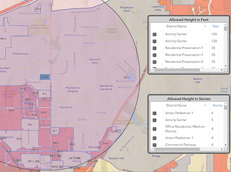
The Live Local Act, passed by the Florida Legislature in 2023, is a statewide strategy to increase affordable housing. If new development includes the required percentage of affordable units, as set by statute, buildings may be as tall as allowed in the highest zoning district within 1 mile. This webmap tool allows the user to select an eligible parcel and find the height allowed on it.

Please note the 2024 Florida Legislature adopted the following amendment to the Live Local Act which could further limit maximum building height. Please contact the Growth Management office for a final determination of allowed height.

FS 166.04151(7)(d):
2. If the proposed development is adjacent to, on two or more sides, a parcel zoned for single-family residential use that is within a single-family residential development with at least 25 contiguous single-family homes, the municipality may restrict the height of the proposed development to 150 percent of the tallest building on any property adjacent to the proposed development, the highest currently allowed height for the property provided in the municipality’s land development regulations, or 3 stories, whichever is higher. For the purposes of this paragraph, the term “adjacent to” means those properties sharing more than one point of a property line, but does not include properties separated by a public road.

Star Tallahassee logo - link to main homepage
  • Contact Info
  • Growth Management
  • 435 North Macomb Street
  • Tallahassee FL 32301
  • 850-891-7001
  • Maps and Directions
  • Contact Us
  • City Commission
  • John E. Dailey, Mayor
  • Jeremy Matlow
  • Jacqueline "Jack" Porter
  • Curtis Richardson
  • Dianne Williams-Cox
  • City Officials
  • Reese Goad
    City Manager
  • Amy M. Toman
    City Attorney
  • Dennis R. Sutton
    Inspector General
  • Jim Cooke
    City Treasurer-Clerk
  • City Services
  • Utility Accounts
  • Parking Tickets
  • Report a Problem
  • TPD Online Reporting
  • Accessibility
  • Email Subscriptions
  • ADA/Non-Discrimination
  • Online Kennel
  • Driver Info Service
  • Athletics Registration
  • Public Records
  • WCOT Online
  • Talgov.com
  • Directory/Site Map
  • Talgov Apps
  • Privacy Policy
  • Disclaimer
  • Site Feedback
  • Employee Login
  • Translate This Site
  • Growth Management
  • 435 North Macomb Street
  • Tallahassee FL 32301
  • 850-891-7001
  • Maps and Directions
  • Contact Us
  • Directory/Site Map
  • Privacy Policy | Disclaimer | Translate This Site
Loading... Loading...